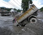
Catastrophic flash floods along the Himalayan border between Nepal and China demonstrate how localized glacial destabilization can rapidly cascade into regional infrastructure failure and massive loss of life. With the verified death toll reaching 469 and over 1,400 individuals unaccounted for, emergency management authorities face severe operational constraints driven by geomorphological destruction and secondary hydrological hazards.
The Mechanics of Glacial-Hydrological Disasters
The disaster originated from a high-altitude glacial collapse that instantaneously displaced enormous volumes of water, rock, and debris into narrow mountain river basins. This hydraulic surge functioned less like a conventional riverine flood and more like a mountain tsunami, carrying high kinetic energy capable of scouring valley floors. In similar developments, we also covered: The Structural Mechanics of Middle East Deescalation.
When massive torrents move through steep gradients like the Bhotekoshi and Trishuli river corridors, they exhibit specific physical characteristics:
- Mass Concentration: High sediment loads transform water into a dense slurry, increasing impact pressure on structural foundations.
- Velocity Amplification: Confined valley walls accelerate flow rates, drastically shortening the warning window for downstream human settlements.
- Infrastructure Choke Points: Bridges, run-of-river hydropower facilities, and narrow gorges act as physical barriers, creating temporary debris dams that eventually fail and release secondary destructive waves.
In Timure and surrounding border areas, survivors reported ground-shaking phenomena immediately preceding the wall of water, indicating that slope failure and mass movement preceded the crest arrival by mere seconds. This brief temporal delta explains the high casualty rate among local administrative workers, residents, and transit populations who had insufficient evacuation time. Al Jazeera has provided coverage on this fascinating subject in extensive detail.
Infrastructure Vulnerability and Industrial Exposure
The geographical placement of economic infrastructure in high-risk Himalayan river valleys introduces systemic risk. Hydropower generation facilities, such as the Trishuli-1 project, are intentionally sited near high-velocity water channels to maximize energy conversion efficiency. However, this structural dependency exposes operations and workforce populations directly to unmanaged upstream hydrological volatility.
The destruction of nearly 40 kilometers of roadways and dozens of bridges fragmented the operational theater. In disaster response logistics, linear asset destruction triggers a cascading failure:
- Access Paralysis: Ground-based heavy machinery cannot reach epicentral zones when arterial roads are pulverized or buried under meters of wet debris.
- Communication Isolation: Power and telecommunication lines running parallel to river valleys are severed instantly, blinding incident commanders to real-time ground conditions.
- Resource Rationing: Helicopters become the sole vector for extraction and supply delivery, creating strict payload limits and weather-dependent scheduling bottlenecks.
Secondary Threat Matrices and Operational Pauses
Emergency response protocols dictate that search and recovery operations must halt when secondary threats exceed acceptable risk thresholds for personnel. Chinese authorities paused rescue work at the epicenter in Tibet due to the formation of an unstable barrier lake.
When water is impounded behind unstructured landslide or glacial debris dams, it forms a high-head reservoir without engineered spillways. The physical variables governing these barrier lakes dictate a high probability of catastrophic breakout:
- Infiltration and Piping: Water percolates through loose debris, eroding internal structural integrity.
- Overtopping: Uncontrolled inflow exceeds the crest's retention capacity, rapidly cutting a channel through the loose material.
- Sudden Failure Wave: The rapid discharge of the impounded volume produces a secondary flash flood that can obliterate downstream search parties operating in riverbeds.
This hydrological reality forced a strategic pivot from immediate rescue to containment and regional relief. Ground teams in Nepal shifted focus toward establishing control rooms, organizing mass medical triage at tertiary hospitals in Kathmandu and Chitwan, and deploying drones to map inaccessible slide zones.
Resource Allocation and International Coordination Deficits
Cross-border disasters introduce acute friction in diplomatic and operational coordination. With hundreds of foreign nationals—including significant cohorts of Indian, American, British, Australian, and Canadian citizens—reported missing or stranded, diplomatic missions must interface directly with localized disaster management authorities.
The tracking of transient populations, such as pilgrims traveling toward Kailash Mansarovar or trekkers navigating remote regional routes, relies heavily on registry data that is rarely synchronized in real-time. Consequently, consular response mechanisms operate on lagging indicators, attempting to reconcile unconfirmed missing-person reports against chaotic evacuation manifests.
Financial mobilization by international bodies, including the release of emergency response funds, addresses immediate medical, shelter, and potable water deficiencies. However, capital injection does not immediately resolve physical access constraints. The primary limiter on operational throughput remains physical geography—specifically, clearing tons of cohesive mud from subterranean tunnels and rebuilding fractured structural spans before heavy equipment can be deployed to stabilize unstable slopes.
Deploy engineering reconnaissance units equipped with radar and seismic sensors to map internal debris stability around the barrier lake before authorizing any resumption of ground-level recovery within high-risk gorge sectors.