Flash flood disasters are fundamentally problems of volumetric rate imbalance, where atmospheric delivery speeds vastly outpace the infiltration capacity of local geography and the drainage thresholds of built infrastructure. When a severe convective system deposits between six and ten inches of precipitation across the Ohio Valley within a compressed multi-hour window, the resulting crisis is predictable. The disaster currently unfolding across Central Kentucky—resulting in at least four confirmed fatalities across Madison and Jackson counties—exposes systemic bottlenecks in civil engineering, hydrological modeling, and emergency deployment protocols.
Understanding this crisis requires moving beyond emotional reporting toward a rigorous framework that evaluates the precise points of failure across infrastructure, topography, and operational mechanics.
The Hydrological Equation: Infiltration vs. Inundation
To accurately evaluate a flash flood, engineers look at the relationship between precipitation intensity and surface saturation, which dictates the runoff coefficient. The disaster in Kentucky is governed by three primary environmental variables that created a compounding failure loop.
- Precipitation Rate Over Time: Convective cells stalled over the region, dropping localized totals of six to seven inches in Kentucky and up to ten inches in neighboring southwestern Indiana. When rainfall exceeds two inches per hour, standard municipal storm sewer systems—typically engineered for 10-year or 25-year storm events—experience immediate backpressure.
- Topographical Funneling: The geography of central and eastern Kentucky features karst topography and steep river valleys. This creates a highly efficient natural drainage network that accelerates velocity. Water that falls on ridges does not infiltrate; it gains kinetic energy as it runs downhill, pooling rapidly in low-lying residential sectors.
- The Baseline Saturation Constant: Prior storm systems throughout June 2026 had already elevated soil moisture profiles. With the upper soil layers near 100% saturation, the ground acted as an impermeable surface, mimicking concrete. Virtually 100% of the newly introduced rainfall was converted directly into surface runoff.
This specific combination explains why urban centers like Richmond experienced rapid structural inundations, including the catastrophic structural failure of the Millon Church. It also demonstrates why subterranean residential units became immediate hazards, directly trapping and killing residents in basement apartments.
Infrastructure Degradation and Mechanical Bottlenecks
Civil infrastructure is built to historical tolerances, meaning it frequently fails when facing unprecedented meteorological anomalies. During this event, the breakdown of physical assets followed a predictable cascade across three distinct sectors.
Structural Transportation Failures
The Kentucky Transportation Cabinet reported at least twelve state roads completely non-operational due to submersion or physical washout. Civil assets fail under flash flood conditions due to hydrostatic pressure and scouring—where fast-moving water undermines the soil supporting road beds and bridge abutments. When water bridges the surface of a road, asphalt lifts due to buoyancy and velocity vectors, severing critical evacuation and rescue corridors.
Earthen Dam Instability
In Bullitt County, emergency officials initiated precautionary evacuations along Cedar Springs Drive due to a landslide on a dam embankment. The structural mechanics of earthen dams are highly sensitive to rapid saturation. When heavy rain falls over a short period, the pore water pressure within the earthen embankment rises, reducing the shear strength of the soil. This triggers localized slope failures or landslides. While the core of the dam may remain intact, the loss of flanking mass introduces structural asymmetry, raising the probability of a catastrophic breach if water levels continue to rise.
The Submergence of Civil Micro-Environments
The urban core of Richmond highlighted a fatal flaw in modern zoning: the exposure of below-grade housing. Subterranean and basement apartments function as macro-drains during flash floods. When street-level stormwater exceeds curb capacities, it follows the path of least resistance, descending stairwells and window wells. This creates rapid hydraulic loading against doors and windows, sealing occupants inside under thousands of pounds of water pressure before structural failure even occurs.
Emergency Response Dynamics and Operational Constraints
When infrastructure fails, rescue operations switch from mitigation to active extraction. The efficacy of this phase is strictly limited by resource constraints and environmental visibility.
First responders face a compounding logistics problem. Local resources, such as the Richmond Fire Department and Madison County emergency crews, face immediate capacity limits during a simultaneous multi-point crisis. To counter this, agencies rely on regional mutual aid agreements, such as deploying the Bluegrass Emergency Response Team. However, these regional assets encounter the same severed transportation corridors as fleeing civilians, creating a spatial bottleneck that delays critical swift-water rescue equipment.
The operational risk increases sharply after sunset. As visibility drops to near zero, boat and helicopter extractions become significantly more hazardous. Rising water masks subterranean hazards like submerged fences, vehicles, and downed power lines, which can capsize rescue vessels or snarl propulsion systems. This operational threshold drove the emergency declaration by Governor Andy Beshear, which focused heavily on a directive to halt civilian transit before dark.
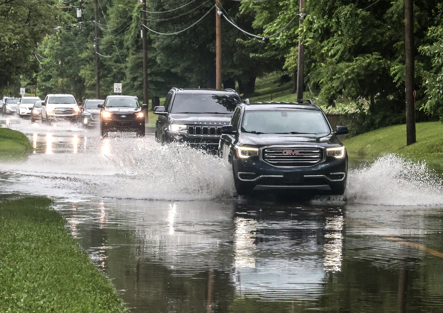
The Fatal Vehicle Vector
A consistent data point in flash flood mortality data is the high percentage of fatalities involving motorists. In this event, at least one death was directly attributed to a driver being swept away by floodwaters. The physics behind vehicle instability in moving water are frequently misunderstood by the public, leading to critical errors in judgment.
A standard passenger vehicle weighing approximately 3,000 pounds experiences two distinct forces when entering moving water: buoyancy and lateral hydrodynamic drag.
[Buoyancy Force] = (Volume of Submerged Vehicle) x (Density of Water)
[Drag Force] = 0.5 x (Density of Water) x (Velocity Squared) x (Drag Coefficient) x (Frontal Area)
Because vehicles contain large volumes of air, they displace a massive weight of water. For every foot of water depth, a vehicle loses roughly 1,500 pounds of effective weight due to buoyancy. Once the water depth reaches two feet, the vehicle loses traction entirely and floats. At this stage, the lateral drag force—which scales exponentially with the velocity of the current—easily overcomes the remaining frictional grip between the tires and the road, sweeping the vehicle downstream into deeper, turbulent waters.
Long-Term Capital Realignment
Traditional emergency responses treat flash floods as anomalous, isolated crises. A technical analysis suggests otherwise: these events expose a permanent mismatch between static infrastructure design and changing atmospheric realities. Moving forward, regional planning must shift funding away from reactive emergency recovery and toward structural retrofitting.
Municipalities must re-engineer stormwater systems using forward-looking dynamic modeling rather than historical averages. This requires expanding green infrastructure to increase infiltration, implementing strict bans on below-grade residential spaces in known floodways, and reinforcing earthen dams with concrete armoring to resist pore-pressure landslides. Until civil infrastructure budget allocations match the physical scale of these compounding meteorological events, localized atmospheric stall patterns will continue to cause catastrophic failures in human transit, housing, and life safety systems.