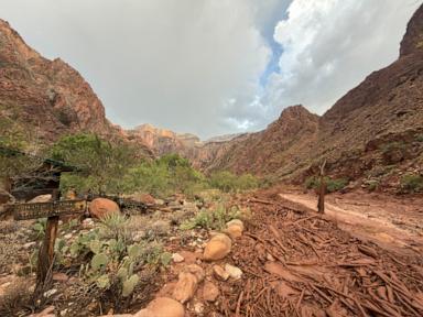
Flash flood dynamics in arid canyons operate on severe physical constraints where topography, precipitation rates, and soil saturation converge to create rapid, high-consequence disasters. When convective storms strike the Grand Canyon region, precipitation cannot infiltrate compacted or hydrophobic desert soils. Instead, water accumulates rapidly in steep, narrow drainage basins, transforming dry washes into high-velocity torrents of debris and water within minutes. This structural reality accounts for why backcountry visitors face fatal risks even when meteorological observations indicate clear skies at their immediate elevation.
The Physical Mechanics of Canyon Hydrology
To understand how localized weather patterns produce catastrophic outcomes in the Grand Canyon, one must examine the hydraulic variables governing runoff generation. Expanding on this theme, you can also read: The Final Distance Between Here and Home.
- Basin Morphometry: The canyon network consists of steep, amphitheater-like side canyons that act as natural funnels. A rain event occurring miles away on the plateau concentrates its discharge into narrow bottleneck channels.
- Soil Infiltration Capacity: Arid lithology often features crusts or baked clay layers that reject moisture. Once surface saturation is reached, infiltration drops to near zero, shifting the runoff coefficient close to 100 percent.
- Time of Concentration: The steep vertical relief minimizes the travel time required for precipitation to reach main drainage paths. Flash flood peaks arrive with little to no latency, invalidating standard evacuation timelines based on visual cues.
When atmospheric moisture combines with localized orographic uplift, convective storm cells stationary over the rim deposit inches of rain in brief intervals. The resulting hydraulic pressure turns normal hiking corridors into hazardous zones. Park management frameworks must account for these variables through strict spatial zoning and real-time hydrological telemetry rather than generalized advisories.
The Failure Modes of Recreational Risk Mitigation
Visitors frequently miscalculate hazard exposure due to cognitive biases regarding weather predictability. The absence of rain at river level provides a false sense of security while storms rage miles upstream. Experts at The Washington Post have also weighed in on this matter.
- Spatial Disconnect: The catchment area producing a flood often experiences entirely different weather conditions than the recreation site. Traditional hazard perception relies on local observation, which fails in vertically stratified terrain.
- Velocity Versus Depth Hazards: Moving water exerts exponential force as depth and velocity increase. A depth of two feet moving at high speed possesses sufficient kinetic energy to sweep away equipped adults and heavy gear.
- Communication Latencies: Emergency messaging systems face propagation delays in remote canyon bottoms where cellular infrastructure is absent. By the time warnings transmit via satellite or physical patrols, the event window has often closed.
Risk mitigation strategies must abandon static safety guidelines. Standard emergency responses assume linear progression, whereas hydrological events in desert canyons exhibit exponential escalation. Operators and independent travelers alike require deterministic decision matrices that mandate immediate vertical evacuation upon the first indicator of upstream precipitation.
The Cost Function of Remote Search and Rescue Operations
Deploying resources into the Grand Canyon environment during or immediately following a flash flood introduces extreme operational friction. Emergency logistics are bounded by severe geographical limits.
- Access Constraints: Helicopters cannot safely navigate narrow slot canyons during active storm cells due to severe downdrafts, low visibility, and turbulence. Ground teams face impassable debris fields and secondary slide risks.
- Communication Blackouts: VHF radio signals reflect poorly off canyon walls, fragmenting command and control structures during multi-agency responses.
- Resource Allocation Trade-offs: Swift-water rescue specialists must be staged proactively rather than reactively, given the compressed response windows dictated by the watershed mechanics.
Agencies responsible for public safety must transition from reactive rescue models to predictive operational postures. This involves deploying automated stream gauges and acoustic sensors at key upper basin confluences to trigger automated warning beacons before water levels crest dangerous thresholds.
Establish mandatory turn-back protocols for high-risk tributaries whenever the National Weather Service issues flash flood watches for the Coconino Plateau. Restrict backcountry permit issuance dynamically based on real-time soil moisture indices and radar-estimated precipitation accumulation rather than monthly seasonal averages.