A 91% drop in wildlife-vehicle collisions along Colorado's Interstate 25 proves that physical grade separation outperforms driver warnings, yet headline coverage treats the overpass as a standalone miracle rather than a coupled system. Standard news reporting stops at the headline figure: a bridge opened, animals used it, and crashes fell. That framing misses the operational architecture behind the result and obscures the measurement blind spots that govern whether the investment holds up over decades.
The blueprint for reading this project rigorously rests on four analytical moves:
- Redefine the asset: Treat the overpass as a node inside a fenced funnel system rather than a solitary bridge.
- Map the causal chain: Separate direct crash prevention from secondary gains in travel reliability, enforcement load, and habitat connectivity.
- Audit the metrics: Distinguish verified carcass and crash reports from unobserved crossings, seasonal migration surges, and reporting gaps.
- Price the constraints: Weigh upfront capital and maintenance obligations against long-term crash avoidance and ecological limits.
Deconstructing the Headline Claim
Headline reports around the Colorado report highlight a 91% drop in wildlife-vehicle collisions over roughly 10 months since the overpass opened. That percentage looks decisive on paper, but a percentage without a baseline and a system boundary leaves out critical mechanics.
In the affected Interstate 25 corridor near Castle Rock, between Larkspur and Monument, prior reporting indicated roughly one wildlife-vehicle crash per day on average before the mitigation system came online, with only two reported collisions in the 10 months following completion. Over 100,000 vehicles travel this stretch of freeway daily through roughly 39,000 acres of surrounding habitat. High traffic volume combined with seasonal movement creates persistent collision exposure whenever animals attempt to cross at grade.
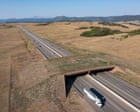
Standard coverage attributes the drop primarily to the overpass itself, described as costing $15 million and ranking as the largest wildlife overpass in North America. Calling the bridge the sole driver is an attribution error. The overpass operates alongside five large wildlife underpasses and miles of 8-foot-tall fencing designed to block direct road entry and channel movement toward safe crossing points.
Consider a simpler analogy from warehouse logistics. Installing a single wide conveyor bridge over a busy forklift lane does little if workers and pallets still cut across the floor at will. You need perimeter barriers to stop shortcuts and guide flow into designated channels. On a high-speed highway, tall fencing acts as the boundary wall, while the overpass and underpasses act as the throughput channels.
The Coupled System Architecture
Effective highway wildlife mitigation functions as a three-part physical system rather than a single monument. Removing any one component degrades the others.
- Grade-separated crossings: The vegetated overpass and five underpasses provide routes above and below traffic streams for species ranging from elk, mule deer, and bears to smaller animals such as rabbits and northern leopard frogs.
- Exclusion and guidance fencing: Miles of 8-foot-tall fencing prevent animals from entering the right-of-way at random points and redirect animals moving along the corridor toward overpass or underpass approaches.
- Corridor habitat context: Surrounding acreage supplies the foraging, cover, and seasonal range that make movement across the highway necessary in the first place.
The causal relationship runs in two directions. First, fencing without sufficient crossings traps animals or forces them to test fence ends, increasing risk along unmitigated segments. Second, crossings without fencing leave animals exposed to high-speed traffic because large ungulates and carnivores do not naturally funnel into a narrow corridor unless guided there.
Why does this matter for drivers and agencies? Because a barrier-plus-crossing design alters animal decision-making before a vehicle ever enters the conflict zone. Instead of reacting to oncoming headlights on pavement, animals encounter a physical boundary that steers them toward lower-stress traversal routes.
Causal Chains Missed by Surface Coverage
Surface reporting often treats safety, ecology, and traffic flow as separate perks. In practice, they form a tightly coupled operational chain.
From Crash Reduction to Operational Relief
When a large animal collides with a vehicle at highway speed, the event triggers a cascade of downstream costs. Drivers face injury risk and vehicle damage; law enforcement must respond and manage hazardous scenes; maintenance crews must clear roadway hazards and carcasses. Reporting around the Colorado corridor notes drops in crashes alongside roughly 9% fewer travel delays and reduced demand on law enforcement and maintenance crews diverting traffic.
The mechanism is straightforward. Fewer crashes mean fewer lane blockages, fewer shockwave slowdowns on a high-volume commuter route, and fewer hours spent by state patrol troopers and road crews on emergency response. Even small reductions in incident-driven congestion carry real value on a route carrying over 100,000 daily vehicles.
From Barrier Permeability to Gene Flow and Range Use
Long highways act as demographic filters. Over time, traffic mortality and avoidance behavior isolate populations on opposite sides of the road. Biologists tracking the corridor noted pronghorn crossing safely after decades of movement constraints along I-25, alongside use by elk, bears, and smaller species.
Reconnecting habitat across a divided landscape does more than spare individual animals from immediate death. It restores seasonal movement paths and supports genetic exchange across fragmented parcels. That ecological effect is a well-established conservation principle in landscape ecology, though measuring long-term population health requires multi-year demographic data beyond a 10-month window.
Timing and Exposure Volatility
Collision risk is not uniform across the calendar. Seasonal migration cycles and shifts in daylight—such as autumn clock changes pushing evening dusk into commuter traffic—concentrate exposure into specific windows. A 10-month post-opening window captures part of the annual cycle, but full evaluation requires comparing identical seasonal peaks across multiple years to separate true structural reduction from short-term variance.
Evidence Audit Facts Versus Hypotheses
Rigorous analysis requires separating what transportation and wildlife agencies have directly observed from broader inferences.
Known facts from agency reporting and coverage:
- Wildlife-vehicle collisions in the tracked corridor fell by 91% in the 10 months after the overpass opened, with two reported collisions during that period compared with an average of one per day prior to construction.
- The mitigation system combines North America's largest wildlife overpass, five wildlife underpasses, and miles of 8-foot fencing along a stretch of I-25.
- Trail cameras, surveys, and agency tracking have documented use by multiple species, including elk, bears, pronghorn, rabbits, and northern leopard frogs.
- State patrol troopers and maintenance crews log crashes and carcass removals, and corridor travel delays declined by about 9%.
Educated hypotheses and open analytical questions:
- Attribution share: The combined system drove the 91% drop, but isolating the exact marginal crash reduction of the overpass alone versus the underpasses and fencing requires controlled corridor modeling.
- Detection completeness: Carcass and crash logs capture reported events and cleared roadkill, yet smaller animals hit off-pavement or unobserved incidents can introduce measurement noise.
- Long-run payback: While infrastructure advocates and research note that crossings can offset costs by preventing expensive crashes over time, exact net present value depends on local crash severity distributions, discount rates, and ongoing maintenance costs.
Operational Playbook for Corridor Planners
Transportation agencies and regional planners evaluating similar high-traffic corridors can apply a disciplined sequence rather than copying a single bridge design.
- Rank corridors by combined crash and movement density. Overlay crash logs, carcass records, traffic volumes, and seasonal animal movement data to pinpoint high-friction segments instead of spreading low-height fencing or signs across entire highways.
- Design the fence-and-crossing network as one engineering package. Pair tall exclusion fencing with overpasses and underpasses spaced to match local species behavior and terrain, avoiding isolated crossings that animals rarely reach.
- Standardize multi-agency data capture. Align highway patrol crash reports, maintenance carcass logs, and wildlife camera or survey observations under shared location segments so safety and ecological outcomes can be audited together.
- Budget for lifecycle upkeep from day one. Include fence inspections, jump-out or escape features where applicable, vegetation management on overpasses, and winter maintenance impacts in capital and operating budgets.
- Audit across full seasonal cycles before declaring steady state. Track performance through peak migration and low-light commuting months across multiple years before extrapolating early percentages statewide.
Limitations and Strategic Trade-Offs
Wildlife crossings are not a universal fix for every highway conflict. Capital budgets are finite, and major structures require substantial upfront funding—$15 million for the Colorado overpass alone—alongside federal or state matching programs and multi-agency coordination.
Physical barriers also introduce operational trade-offs. Long fencing can alter drainage patterns, complicate right-of-way maintenance, or create conflict points if poorly maintained or improperly tied into terrain and crossings. Furthermore, building a crossing does not stop broader regional land development; if adjacent habitat is subdivided or degraded, crossing structures cannot manufacture viable habitat on their own.
Where collisions are concentrated on high-volume corridors slicing through active habitat, grade-separated crossings paired with exclusion fencing offer one of the highest-leverage physical interventions available. The strategic play for transportation leaders is to treat early results like Colorado's 91% reduction as proof of system mechanics—then fund the next projects strictly by crash-cost density, full-system fencing integration, and multi-year lifecycle accounting rather than chasing record bridge dimensions.