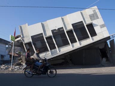
When a magnitude 7.7 earthquake struck East Nusa Tenggara at a shallow depth of 10 kilometers, the immediate physical kinetic energy released was compounded by structural bottlenecks across regional supply chains. Resulting in at least 54 fatalities, over 1,300 damaged housing units, and the displacement of 5,000 individuals across Flores Island, the seismic event coincided precisely with national independence observances. This temporal alignment exposed the vulnerability of emergency response systems when operational bandwidth is split between ceremonial obligations and immediate humanitarian triage.
Disaster response in island nations operates as a complex distribution network function. When maritime routes, steep topography, and single-point infrastructure nodes collide with tectonic volatility, standard humanitarian logistics models fail. Deconstructing the Flores crisis reveals the precise failure modes that impede rapid relief delivery during major tectonic shocks.
The Three Structural Bottlenecks of Island Disaster Logistics
Emergency response efficacy in archipelagic topographies is bounded by three distinct friction variables: nodal concentration, topographical constriction, and data latency.
Nodal Concentration and Hub Saturation
The primary failure point in the initial seventy-two hours following the East Nusa Tenggara tremor involved logistics consolidation bottlenecks. Relief supplies managed by the National Disaster Mitigation Agency were pooled at central staging grounds, specifically Jakarta's Halim Perdanakusuma Air Base, before being pushed to regional hubs in Labuan Bajo and Maumere.
While central stockpiling ensures inventory control, it introduces systemic transit latency. Secondary and tertiary distribution nodes on Flores Island, such as Manggarai and Sikka districts, rely on linear transit corridors. When those corridors face blockages, the entire distribution network stalls. The deployment of 3,500 military and personnel alongside 275 tons of aid represents high aggregate resource allocation, but aggregate volume is a vanity metric if throughput velocity remains constrained by single-lane transit chokepoints.
Topographical Constriction and Geotechnical Failure
Flores Island is characterized by steep volcanic terrain, making its infrastructure highly susceptible to secondary seismic hazards. The 7.7-magnitude tremor triggered extensive landslides that hurled boulders across roadways and severed critical land routes connecting isolated pockets like Reo and Palue Island.
Geotechnical failure turns transport networks into discrete, disconnected pockets. When roads are blocked by debris and steep gradients prevent heavy vehicle movement, mechanical clearing speed dictates the rate of relief arrival. In remote zones such as Palue Island, access required hazardous multi-modal journeys across sea and landslide-impacted terrain. The logistical friction coefficient of these routes spikes exponentially post-quake, rendering standard supply chain assumptions invalid.
Assessment Latency and Demand-Signal Distortion
Resource allocation efficiency depends on real-time damage quantification. In the immediate aftermath of the Flores event, regional authorities prioritized rapid structural impact assessments, specifically categorizing homes with mild, moderate, or severe damage.
However, a structural information gap occurs when displaced populations require immediate consumables—potable water, medical supplies, and cooking equipment—while data collection teams focus on macro-infrastructure damage. Survivors in temporary tarpaulin camps reported receiving raw food aid without the necessary cooking apparatus or clean water access, leading to secondary public health vulnerabilities such as childhood diarrhoea. This mismatch proves that demand-signal processing lagged behind physical asset deployment.
The Seismological Cost Function
The disaster's severity is a direct output of fault dynamics interacting with human settlement patterns along the Pacific Ring of Fire. The parameters of the Flores event dictate the operational constraints faced by rescue teams:
- Focal Depth: At 10 kilometers deep, the hypocenter released maximal destructive energy near the surface, amplifying peak ground acceleration across localized structural footprints.
- Aftershock Frequency: The recording of nearly 1,600 aftershocks (with hundreds formally logged) introduced psychological and physical deterrence. Populations were forced to remain outdoors under tarpaulins, refusing to re-enter structurally compromised buildings, which multiplied temporary shelter requirements.
- Historical Memory Decay: The 1992 Flores earthquake and tsunami, which resulted in approximately 2,500 fatalities, established a baseline risk profile that communities remembered, yet structural zoning and retrofitting enforcement across rural regencies remained suboptimal, as evidenced by the high volume of collapsed residential masonry.
The Economic Impact Matrix of Displaced Labor
When thousands of individuals are displaced into temporary camps, regional economic productivity drops to zero. Micro-enterprises, such as trading and local commerce represented by vendors in Reo, experience total asset liquidation when physical storefronts collapse into rubble.
The economic recovery function is not linear. It requires balancing immediate fiscal cash transfers for basic survival with capital injections for structural reconstruction. Traditional insurance penetration in rural East Nusa Tenggara is negligible, meaning the entirety of the financial shock is absorbed directly by household savings and state-backed disaster response funds. Consequently, a two-week state of emergency declaration serves as a regulatory pause, but true economic rehabilitation requires institutional credit relief and structural building code enforcement that withstands high-magnitude seismic events.
Strategic Operational Recommendations for Archipelagic Resilience
To eliminate the distribution friction observed during the Flores crisis, regional disaster management frameworks must transition from centralized reactive staging to decentralized predictive prepositioning.
- Decentralized Micro-Hubs: Shift perishable medical supplies and water filtration assets from national airbases to pre-engineered, seismic-resistant modular depots located directly within high-risk regencies like Manggarai and Sikka before disaster strikes, bypassing primary road network dependencies.
- Autonomous Aerial Corridors: Integrate heavy-lift autonomous drone logistics for the first 48 hours following a seismic event in mountainous terrain. When landslides block arterial roads, aerial delivery of cooking equipment, water purification units, and medical trauma kits eliminates dependence on road clearance timelines.
- Dynamic Triage Protocols: Decouple physiological survival aid distribution from structural damage assessment surveys. Establishing mandatory public kitchens and sanitation modules within the first twelve hours prevents secondary health crises in temporary camps regardless of whether macro-infrastructure data has been fully compiled.


