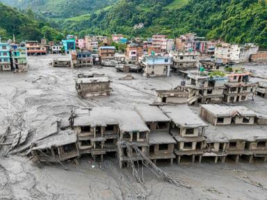
Dozens of American citizens are currently unaccounted for following a catastrophic wall of water and debris that tore through the mountainous terrain of the Nepal-Tibet border. The disaster, triggered by a massive glacial collapse, sent tsunami-like torrents crashing down river valleys, instantly obliterating roads, bridges, and remote settlements.
As local authorities and international agencies scramble to map the scope of the emergency, numbers shift by the hour. Nepal's tourism board and diplomatic channels confirm that at least 63 Americans are among the hundreds of foreign nationals out of contact in the rugged Rasuwa district and surrounding areas.
Yet, untangling the casualty statistics from the logistics of total communication blackouts remains a grueling challenge. In high-altitude disaster zones, a missing person designation often means a severed phone line rather than a confirmed fatality. Still, the rising death toll points to a disaster of historic proportions for the region's fragile infrastructure.
The Anatomy of a Himalayan Catastrophe
The disaster unfolded without warning along critical transit and trekking corridors. At approximately 8:30 in the morning, a massive block of ice and rock detached from a high-altitude glacier. This sudden movement crashed into the valleys below, destabilizing water systems and sending a catastrophic surge through the Bhote Koshi and Trishuli river basins.
Water levels in localized downstream zones spiked by nearly nine meters in a matter of thirty minutes. For villagers preparing for their morning routines and tourists navigating the high-altitude trails, escape was virtually impossible.
The geography of the border region exacerbates every facet of the rescue effort. Steep gorges, narrow mountain passes, and destroyed road networks mean that heavy machinery cannot reach the hardest-hit settlements. Helicopters form the primary lifeline, ferrying emergency supplies and attempting daring extractions where landing zones barely exist.
This specific corridor serves a dual purpose. It functions as a vital economic and cultural artery connecting Kathmandu to Lhasa, drawing thousands of pilgrims toward sacred sites like Mount Kailash alongside independent trekkers. The convergence of seasonal travelers and remote geography turned a localized environmental event into an international emergency.
The Paper Trail of Missing Persons
Tracking foreign nationals across isolated Himalayan outposts exposes the administrative vulnerabilities inherent in global adventure tourism. In the immediate aftermath of the flooding, initial tallies cited only a handful of missing citizens based on alerts from localized tour operators. As regional authorities consolidated reports from disparate trekking agencies, police posts, and consular offices, that number climbed past sixty.
Diplomatic missions face a unique information vacuum. The United States State Department has urged citizens in the affected districts to establish contact with family members or local guides immediately. However, with power grids knocked offline and cellular towers swept away, silence does not automatically equate to tragedy.
Local police and disaster management authorities continue to balance two competing registers: those confirmed dead and those listed simply as out of contact. This distinction offers a slim margin of hope for families waiting thousands of miles away, even as search crews pull bodies from the thick mud deposits left behind by the receding waters.
Climate Pressures and Structural Vulnerabilities
While natural disasters in the Himalayas are historically common during monsoon cycles, scientists emphasize that the mechanics driving these events are shifting. Glacial collapses and sudden outbursts from high-altitude lakes are increasingly tied to broader environmental pressures. Warming temperatures destabilize ice masses that have remained anchored for centuries.
When these structures fail, they release millions of cubic meters of water and debris instantaneously, overwhelming valleys that lack modern early-warning sensors. Hydropower plants constructed along these rivers often bear the brunt of the kinetic force, disintegrating into twisted metal and adding hazardous debris to the floodwaters.
Engineers and disaster risk specialists have long warned that rapid infrastructure development in narrow mountain gorges outpaces climate risk assessments. Roads cut into steep hillsides and energy projects lining riverbanks sit directly in the path of historical and prehistoric flow channels. When a glacial collapse occurs, these projects offer zero resistance, effectively turning industrial components into shrapnel carried downstream.
The Limits of International Aid
In response to the unfolding tragedy, foreign governments have mobilized financial and logistical support. The United States pledged emergency humanitarian assistance directed through relief organizations operating on the ground, while regional powers like India and China coordinate cross-border rescue operations.
Yet, money and diplomatic solidarity hit hard operational limits when confronted by five feet of dense mud choking mountain roads. International search and rescue teams must navigate bureaucratic hurdles alongside physical hazards. Coordinating assets across the Nepal-Tibet border requires high-level diplomatic clearance that can slow down deployment during the golden hours of a crisis.
Local security forces and civilian volunteers shoulder the heaviest burden, navigating treacherous terrain with minimal equipment to search collapsed buildings and riverbanks. Their efforts highlight the stark contrast between high-level international financial pledges and the gritty, boots-on-the-ground reality of disaster response in the high Himalayas.
Emergency responders continue to clear debris from arterial routes as weather conditions fluctuate, dictating whether rescue helicopters can safely enter the narrow gorges where dozens of foreign nationals and local residents remain unaccounted for.