The air doesn't just get hot in the Deep South; it gets heavy. It’s a weight you wear like a wet wool blanket, pressing against your chest until every breath feels like a choice. By mid-afternoon in Alabama, the silence is what usually gives it away. The birds stop. The cicadas, those relentless drummers of the heat, go mute. You look at the horizon and see a hue that shouldn't exist in nature—a bruised, sickly emerald that signals the atmosphere is no longer behaving.
Most people see a weather map and see colorful blobs of red and purple moving across a screen. They hear a meteorologist talk about "supercell development" or "enhanced risk zones." But for those living in the path of the current system carving its way through the Gulf States, those terms are bloodless. They don't capture the smell of shredded pine needles or the way your ears pop when the pressure drops so fast it feels like the house is being sucked into a vacuum.
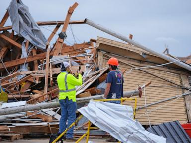
The South is currently bracing for a second wave of violence from the sky. Just hours ago, the first round left behind a trail of splintered lumber where family rooms used to be. Now, the atmosphere is recharging. It’s a cruel physics experiment. The warm, moist air from the Gulf of Mexico is surging north, sliding under the cold, dry air screaming off the Rockies. When they meet, they don't just mix. They explode.
The Anatomy of a Second Chance
Consider a person we will call Elias. He lives in a small town outside of Jackson, Mississippi. Last night, Elias sat in a bathtub with a mattress over his head while the wind roared like a freight train—the cliché is a cliché because it is hauntingly accurate. The storm passed. He stepped outside to find his mailbox gone and his neighbor’s oak tree resting on a power line. He felt the rush of survival. The "I’m okay" phone calls were made.
But the danger of the current weather pattern is the "double-tap." The first line of storms wasn't the finale; it was the opening act. Because the sun came out after the first round, the ground heated up. That heat is fuel. It’s high-octane gasoline for the next cell of thunderstorms. The meteorological data shows a Significant Tornado Parameter (STP) climbing into the danger zone, a numerical representation of how much energy is waiting to be converted into rotation.
Elias, like thousands of others, is now facing "warning fatigue." It is a psychological phenomenon as dangerous as the wind itself. When you spend six hours in a state of high alert and nothing happens to your specific rooftop, the adrenaline fades. You get tired. You want to sleep in your bed, not on the floor of a windowless closet. But the radar doesn't care about exhaustion.
The science of these storms has improved drastically, but the human element remains the wildcard. We have Doppler radar that can see debris being lofted thousands of feet into the air—a "debris ball" that confirms a tornado is on the ground even in the pitch black of night. We have lead times that have stretched from minutes to nearly half an hour. Yet, when the siren wails at 2:00 AM, the gap between knowing and acting is where the tragedy hides.
The Invisible Stakes of the Night
Nighttime tornadoes are twice as likely to be fatal. It’s simple, terrifying math. You cannot see the wall cloud. You cannot see the power flashes as transformers blow, lighting up the funnel in brief, strobe-like bursts of blue and green. You are relying entirely on a piece of technology on your nightstand to wake you up before the roof leaves the rafters.
Across Georgia and the Carolinas, emergency management teams are looking at "convective inhibition"—or the lack thereof. The "cap" in the atmosphere has broken. This means there is nothing to stop the warm air from rising rapidly, cooling, and condensing into massive, rotating towers of energy. These aren't just rain clouds. They are heat engines.
Think about the energy involved. A single large thunderstorm contains the energy of several atomic bombs. We live alongside these giants, usually in a state of peaceful coexistence, until the shear—the change in wind speed and direction with height—starts to twist those rising currents.
Beyond the Plywood and Nails
There is a specific kind of grief that comes with a tornado that doesn't exist with a fire or a flood. A fire leaves ashes. A flood leaves mud. A tornado leaves a void. It takes the physical evidence of a life—the wedding albums, the jars of spices, the high school trophies—and scatters them across three counties.
When we talk about the South bracing for more weather, we are talking about the mental toll of the "waiting room." It is the hours spent watching the local news, staring at the "hook echo" on the radar, and wondering if this is the one that turns your world into a pile of toothpicks.
The economic impact is often cited in the hundreds of millions. Insurance adjusters will descend. Chainsaws will provide the soundtrack for the next two weeks. But the statistics miss the way a community's heart rate spikes every time the wind picks up for the next five years. They miss the "storm anxiety" that children develop, clutching their shoes and a flashlight every time a gray cloud appears on the horizon.
Current projections show the threat shifting eastward as the cold front pushes through. The risk isn't just the "big one." It’s the straight-line winds—microbursts that can hit with the force of a Category 1 hurricane without ever forming a funnel. It’s the hail the size of baseballs that shatters windshields and kills livestock.
The Weight of the Watch
Meteorology is a game of probabilities. When a "Watch" is issued, it means the ingredients are in the bowl. When a "Warning" is issued, it means the cake is in the oven. Right now, a massive portion of the American South is sitting in the kitchen, smelling the smoke, and waiting to see if the house catches fire.
The infrastructure of the South is uniquely vulnerable. While newer homes are built to better codes, thousands of people live in manufactured housing that offers almost zero protection against an EF-2 tornado or higher. For these residents, "sheltering in place" isn't an option. They have to decide between staying put or driving through a deluge to reach a community shelter, risking being caught in their cars—the deadliest place to be during a wind event.
The storm will pass. The sun will eventually rise on a landscape that looks different than it did the day before. Some will find their homes intact, saved by a literal twist of fate or a shift in the wind of half a degree. Others will stand on a concrete slab, looking at the sky, wondering how something so beautiful and blue could have been so violent just a few hours earlier.
The sirens are beginning to sound again in the distance. It is a lonely, haunting wail that cuts through the humidity. It’s a reminder that we are small. We are temporary. We are at the mercy of a restless atmosphere trying to find its balance, indifferent to the lives tucked into the valleys and hills below.
Put your shoes on. Grab your helmet. Get to the lowest floor. The sky is turning green again.