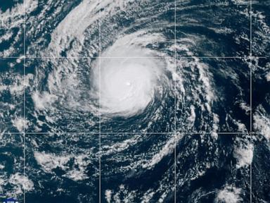
When Hurricane Nolo carved its path across the vast expanses of the Pacific Ocean, meteorologists watched a masterclass in atmospheric persistence. Long-tracking storms like Nolo do not merely materialize and dissipate within a tidy, localized window. They travel thousands of miles, crossing ocean basins, altering regional weather patterns, and challenging the predictive limits of modern numerical models. While initial reports focused narrowly on temporary intensity shifts, the deeper story of Nolo lies in its trans-basin journey and the thermodynamic conditions that allowed it to survive well past its expected expiration date.
Most tropical systems follow a predictable arc. They form over warm tropical waters, mature, approach land or cooler northern waters, and rapidly decay. Nolo chose a different script. Originating far to the east before migrating across the Central Pacific and eventually crossing the International Date Line to become a typhoon, this system exposed the hidden vulnerabilities in how ocean-atmosphere interactions are monitored across remote maritime zones. For a different perspective, read: this related article.
The Anatomy of a Trans-Basin Survivor
To understand why Nolo commanded such intense scrutiny from forecasters, one must look at the mechanics of upper-level steering currents and sea surface temperature anomalies. Storms require specific ingredients to maintain structural integrity over weeks rather than days. Low vertical wind shear, abundant moisture channels, and sustained oceanic heat content act as the primary fuel sources.
As Nolo tracked westward, it encountered pockets of hostile dry air and shifting shear vectors that should have torn its core apart. In many standard scenarios, these atmospheric roadblocks induce rapid weakening. Yet, Nolo repeatedly cheated decay. Further coverage on this trend has been published by The New York Times.
The storm underwent cycles of eyewall restructuring that baffled satellite analysts. Instead of succumbing to entrainment, the convective bands reorganized, locking moisture into a tight, symmetric ring. This resilience highlights a broader truth about modern meteorology. Our baseline assumptions regarding storm longevity are routinely tested by oceanic anomalies that defy standard seasonal curves.
The Operational Blind Spots of the Open Ocean
Forecasting a storm like Nolo presents a logistical nightmare for agencies like the National Hurricane Center and the Joint Typhoon Warning Center. When a hurricane churns thousands of miles away from major continental landmasses, direct data collection becomes sparse. Radar coverage is virtually non-existent over the open deep ocean. Forecasters rely heavily on satellite scatterometry, infrared imagery, and occasional aircraft reconnaissance flights if the system threatens populated territories like the Hawaiian Islands.
This data desert introduces significant margin of error into intensity and track forecasts. When a system undergoes secondary intensification far out at sea, land-based infrastructure gets a brief reprieve, but maritime and aviation interests face sudden navigational hazards. Commercial shipping lanes and trans-pacific flight paths must constantly adjust vectors to steer clear of high-amplitude swells and violent outer rainbands. Nolo generated massive ocean swells that propagated far ahead of the storm center, impacting distant atolls and coastal shelves long before the core winds arrived.
Rethinking Seasonal Vulnerabilities
The arrival of a system like Nolo underscores the shifting dynamics of Pacific tropical meteorology. Observers often categorize storms by their peak wind speeds on the Saffir-Simpson scale, reducing complex meteorological events to a single digit. However, this metric obscures the true footprint of long-duration systems. A storm that persists for weeks alters thermal energy distribution across entire ocean sectors, churning cooler deep water to the surface and leaving a distinct thermodynamic footprint in its wake.
As ocean temperatures continue to fluctuate under the influence of broader climatic cycles, the frequency and behavior of trans-basin wanderers demand closer academic and operational examination. The traditional boundaries dividing Eastern Pacific hurricanes, Central Pacific systems, and Western Pacific typhoons are increasingly fluid. Storms do not respect administrative mapping lines drawn on meteorological charts.
Emergency managers and coastal planners must account for these extended timelines. Preparedness cannot stop simply because a system moves out of immediate range of local radar networks. The lingering swells, peripheral moisture surges, and unpredictable regeneration patterns prove that the life cycle of a major Pacific cyclone extends far beyond its initial peak.
The remnants of Nolo eventually completed their long transition, merging into the broader flow of northern latitude westerlies after a multi-week odyssey. What remains is a reminder of the raw, untamed energy moving constantly across the world's largest marine expanse, operating largely unseen until its power forces our collective attention back to the water.